You are here
Blizzard pounds New York, brings record tides in New Jersey
By Reuters - Jan 23,2016 - Last updated at Jan 23,2016
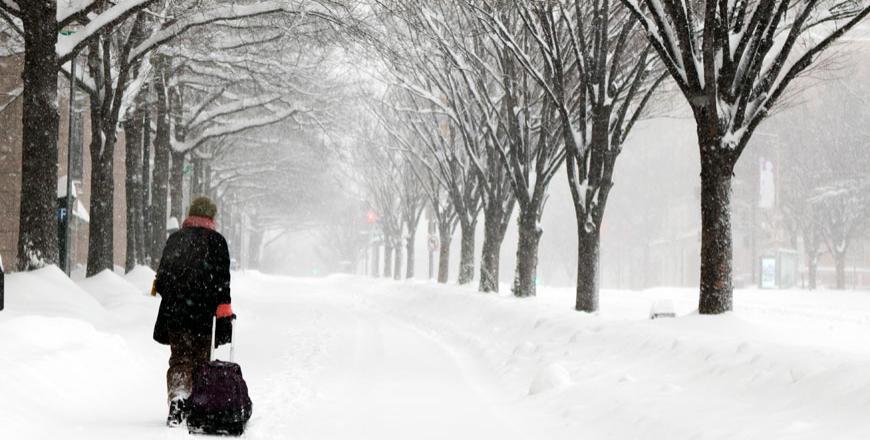
Michelle Navarre Cleary pulls a bag as she walks on K Street in Washington on Saturday as snow continues to fall (AP photo)
NEW YORK/WASHINGTON — A winter storm on Saturday whipped up record-setting tides higher than during Superstorm Sandy, causing major flooding in New Jersey and Delaware after dumping nearly 60cm of snow on the suburbs of Washington, DC.
The heaviest snow engulfed New York on Saturday and was not expected to stop until Sunday, when up to 76cm may have piled up in the nation's largest city, said New York Mayor Bill de Blasio.
The mayor said the storm had strengthened beyond earlier expectations in terms of accumulations and intensity.
New York City buses operated by the Metropolitan Transportation Authority were due to be suspended at noon as the storm bore down on the city.
New Jersey Transit, earlier on Saturday, suspended all bus, rail and light rail service. Earlier the Washington Metropolitan Area Transit Authority, which includes the country's second-busiest subway system, took the rare step of suspending operations through Sunday.
Nearly 4,300 US flights were cancelled, including virtually all travel into New York City airports, according to the FlightAware.com tracking website and transportation officials.
New York Governor Andrew Cuomo declared a state of emergency on Saturday, the 11th state to do so in order to get a handle on highways made impassable by the drifting snow and to shore up coastal areas where the blizzard conditions raised the danger of flooding.
White-out conditions prompted officials to urge residents to stay inside and allow snow plows to clear roads.
"Our message, and we need the public to listen, is to stay home and to stay off the streets. That includes people who are attempting to drive, but it also includes people who are walking," said Washington Mayor Muriel Bowser.
However, some residents said they just couldn't resist seeing famous monuments frosted with snow.
"We haven't made snow angels yet, but we're looking forward to doing that in front of the White House," said Robert Bella Hernandez, 38. "We're just going to walk around, see some snow-covered DC landmarks. And then when it's unsafe, maybe go back in for a minute."
High winds battered the region, reaching 112 kilometres per hour in Wallops Island, Virginia, late on Friday, and whipping up the tides, said meteorologist Greg Gallina of the National Weather Service.
Tides higher than those caused by Superstorm Sandy caused major flooding along the Jersey Shore and Delaware coast and set records in Cape May, New Jersey, and Lewes, Delaware, said NWS meteorologist Patrick O'Hara.
A high tide of 273cm was recorded at 7:51am Saturday at Cape May — slightly higher than the record of 271cm previously set by Sandy on October 29, 2012. A high tide of 282cm was recorded at Lewes, higher than the 280cm high tide recorded in March 1962.
"All the factors that affect the tides, it's all happening at once," O'Hara said.
Even so, there were no reports of evacuations along the New Jersey Shore, where thousands of residents had to abandon their homes during the devastating 2012 superstorm.
The barrier islands in Atlantic County were experiencing significant tidal flooding, said Linda Gilmore, the county's public information officer, affecting Atlantic City and at least four other towns. While the county typically sees flooding during nor'easter storms, the current situation more dangerous than usual.
Gilmore said the risk would grow more severe with each high tide through Sunday morning, but at present it was too early to draw any comparisons with Sandy.
At least eight people were killed in car crashes due to icy roads in North Carolina, Kentucky, Tennessee and Virginia, and a ninth person died of a heart attack while shoveling snow in Maryland. The Pennsylvania National Guard was called in to help stranded motorists along I-78 in the western part of the state, local media reported.
The worst appeared to be over for Washington, although moderate snow was expected to keep falling until late Saturday, with the deepest accumulation of 58cm recorded in Poolesville, Maryland, north of the nation's capital. Snowfall measured 33cm near the White House and 8.89cm near the National Mall on Saturday morning, the NWS reported.
Record storms
"Records are getting close — we're getting into the top five storms," Gallina said.
The record high of 71cm of snow in the nation's capital was set in 1922 and the deepest recent snowfall was 45cm in 2010.
Many stores were left with bare shelves as residents stocked up on food, water and wine, preparing to spend the weekend indoors.
The governors of New York, New Jersey, Pennsylvania, Maryland, Virginia, North Carolina, Georgia, Delaware, West Virginia, Tennessee, Kentucky, and the mayor of Washington, declared states of emergency. Officials warned people not to drive.
The storm developed along the Gulf Coast, dropping snow over Arkansas, Tennessee and Kentucky on Friday. On the East Coast, warm, moist air from the Atlantic Ocean collided with cold air to form the massive winter system, meteorologists said.
The storm was forecast to move offshore in southern New England early next week. Philadelphia and New York were expected to get up to 45.7cm of snow before the storm abated.
Related Articles
WASHINGTON/NEW YORK — Washington will need several more days to return to normal after a weekend blizzard dropped more than 60cm of snow alo
New York — A massive blizzard that claimed at least 16 lives in the eastern United States finally appeared to be winding down Sunday, giving
A blizzard swept across the northeastern United States on Tuesday, dropping as much as 60cm of snow across Massachusetts and Connecticut even as its impact on New York City fell short of dire predictions.


