You are here
Pella: A Bronze Age hub unveiling ancient networks
By Saeb Rawashdeh - Dec 16,2023 - Last updated at Dec 16,2023

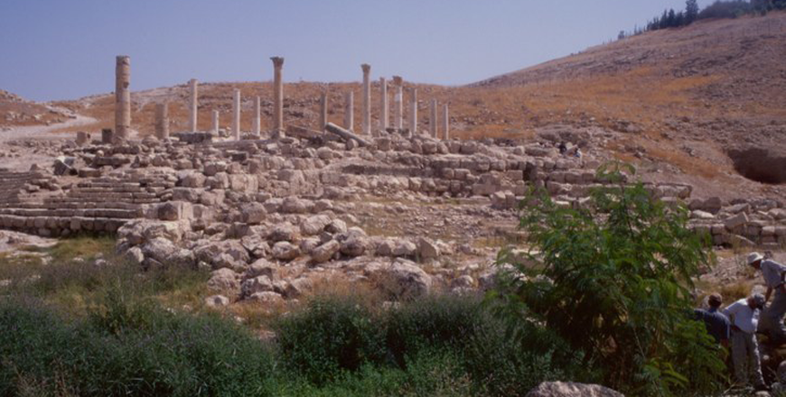
Civic complex Church and monumental staircase (Photo courtesy of ACOR/Rami Khouri Collection)
AMMAN — On the foothills of the East Bank is located the Middle Bronze Age (2000-1500 BC) site Pella. Pella was a hub for trade with Egypt and Cyprus, Anatolia and Babylonia. Significant movements of populations throughout the Middle Bronze Age (MBA) were evidenced through funerary rituals and architecture.
Scholars specialised in the Bronze Age Levant speculated that the trade between different regions was organised through a network of smaller settlements and towns.
“Some researchers have asserted that within the general network, particular nodal sites were more critically important to the direction and regulation of trade-flow, deeming these sites ‘gateway communities’,” noted Chris Chantis from the University of Utah, adding that more specific to the MBA southern Levant was trade with Egypt.
When the Thirteenth Dynasty took over in Egypt, it adopted a more outward-facing stance which directly reflected on the commerce with southern Levant in general and Pella in particular.
Maritime trade along the Levantine coast with littoral ports as the essential nodes (the “port-power” model) is the assumed model, Nina Maaranen from The University of Sheffield said, adding that in the later Middle Bronze Age, when the Hyksos rose to power in the Nile Delta, more particular links between the central driver — the Hyksos capital of Avaris (Tell Al Dab’a) — and inland south Canaanite nodes emerged, which was documented by goods such as scarabs.
The site of Pella consists of a central settlement mound of perhaps six hectares in the MBA, suggesting a town population of perhaps 1,200 at its greatest extent, not including off-site village and farmstead dwellings, which may double that estimate, Chantis said, adding that Pella was blessed with a perennial spring and set beside extensive arable farmlands to the north and west, along with flourishing horticultural zones in the hills to the east and south.
Because of that, Pella enjoyed a mild climate with plentiful winter rainfall, ideal for the mixed agriculture practiced in the MBA. The hills and plains surrounding the site were dotted with farmsteads and forts, small villages and fields, in a territorial unit that very probably stretched from the Jordan River to the arid uplands in the east.
Major trade routes, both east–west and south–north, crisscrossed this territory, linking Pella to both the Mediterranean coastlands and the Jordanian uplands. Therefore Pella was placed in the Levantine trading network and the city was recognised as the primary “gateway” community through which traded goods passed into Jordan from the Mediterranean world.
Numerous studies have emphasised the number and variety of foreign goods found at Pella through the ages. Long distance trade and/or contact is highlighted by the royal name scarabs, centering on links between Pella and the Hyksos capital at Avaris in Egypt, highlighted Professor Stephen Bourke from The University of Sydney.
Funerary objects dicovered in Pella’s tombs came from Greece, Cyprus, Egypt and Mesopotamia, which was the evidence of a very active trade links.
Pella provides valuable information about the late MBA trade direction, intensity and the varying strengths of nodal relationships, noted Maaranen.
Related Articles
AMMAN — Trade and trade networks had a great impact in linking civilisations to both urban centres and undeveloped peripheries, said a Jorda
AMMAN — The Jordan River was “never the border or an obstacle” between the west and east banks and the population and goods freely crossed,
AMMAN — For Italian archaeologist Marta D’Andrea from Sapienza University of Rome, the passage from the Early Bronze Age to the Middle Bronz


